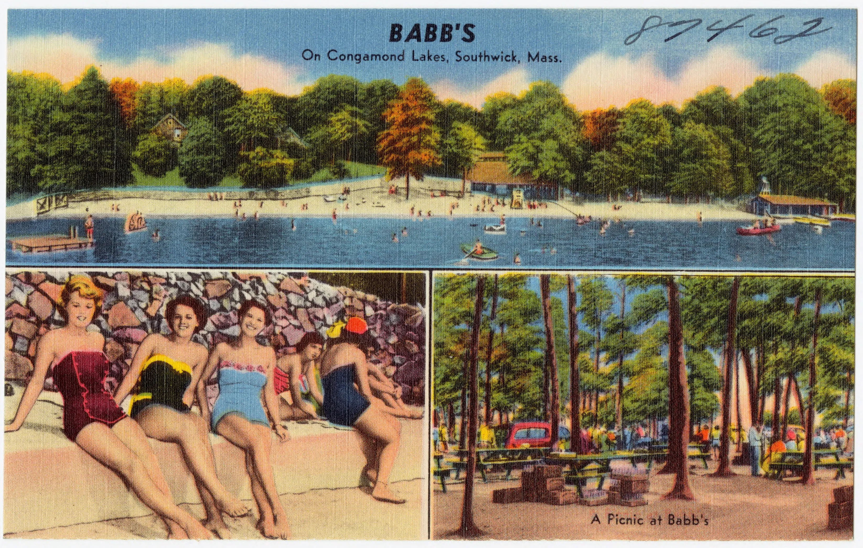
pioneervalley.org

Section

Towns

Hubs for the cities and towns of the Pioneer Valley: what's here, where to go, and what the locals know.

Towns
69
Counties
3
Hampden County

Agawam

A Hampden County city of about 28,700 across the Connecticut River from Springfield. Home to Six Flags New England (the oldest park in the chain), Robinson State Park along the Westfield River, and an 1805 Federal-era tavern attributed to Asher Benjamin in the original village center.

Pop. 28,692

Hampshire County

Amherst

A college town built around UMass, Amherst College, and Hampshire College's closing campus, with conservation land, farm stands, and one of the country's best-known poets in residence.

Pop. 39,263

Franklin County

Ashfield

A small Franklin County hill town of about 1,700 in the southwest corner of the county. Home to the village green and Main Street storefronts of Ashfield Plain along Route 116, the 37-acre Ashfield Lake with the town beach, and a long literary tie to Harvard art historian Charles Eliot Norton, who summered here for nearly four decades.

Pop. 1,695

Hampshire County

Belchertown

A town of about 15,000 on the eastern edge of Hampshire County, anchored by a long colonial common, a 19th-century carriage-making history, and the south-end gates to the Quabbin Reservoir watershed.

Pop. 15,350

Franklin County

Bernardston

A small Franklin County town of about 2,100 at the Vermont line. It is the northernmost Pioneer Valley town along the I-91 / U.S. 5 corridor before the state line, with Cushman Park at its center, the 1856 Powers Institute on the green, and the Fall River winding south through the village toward Greenfield.

Pop. 2,102

Hampden County

Blandford

A small Hampden County hill town of about 1,200 in the eastern Berkshire foothills above the Westfield River. Incorporated in 1741, home to the long-running Blandford Fair, the Henry Knox Trail route, and a Massachusetts Turnpike service plaza on Interstate 90.

Pop. 1,215

Hampden County

Brimfield

A Hampden County town of about 3,700 in the eastern Pioneer Valley along U.S. Route 20, best known for the Brimfield Antique Flea Markets, the largest outdoor antiques show in New England, and home to Hitchcock Free Academy, Brimfield State Forest, and Steerage Rock on the old Bay Path.

Pop. 3,694

Franklin County

Buckland

A small Franklin County hill town of about 1,800 along the south bank of the Deerfield River. Home to the south half of Shelburne Falls village, the upland farms and church-on-a-hill of Buckland Center, and the birthplace and early teaching home of Mary Lyon, who later founded Mount Holyoke College.

Pop. 1,816

Franklin County

Charlemont

A small Franklin County hill town of about 1,200 in the Deerfield River valley at the western edge of the Pioneer Valley. It's the gateway to the Mohawk Trail, home to the 1932 Hail to the Sunrise statue, the Bissell Covered Bridge, the Berkshire East ski area, and the commercial whitewater rafting on the Deerfield.

Pop. 1,185

Hampden County

Chester

A small Hampden County hill town of about 1,200 in the West Branch Westfield River valley. Incorporated in 1765 as Murrayfield and renamed Chester in 1783, shaped by the 1841 arrival of the Western Railroad and its surviving 1840s stone arch bridges, and home to the 60-foot Sanderson Brook Falls.

Pop. 1,228

Hampshire County

Chesterfield

A small Hampshire County hill town of about 1,200 in the upland country between the Westfield River branches and the Mill River headwaters, best known to visitors for the granite chasm of Chesterfield Gorge and a well-preserved Federal-period town center along Main Road.

Pop. 1,186

Hampden County

Chicopee

A small Hampden County city of about 55,000 at the confluence of the Chicopee and Connecticut rivers, with Polish-American and French-Canadian heritage, a 19th-century industrial spine that turned out Civil War swords and bronze castings for the U.S. Capitol, and the home of Westover Air Reserve Base.

Pop. 55,560

Franklin County

Colrain

A small Franklin County hill town of about 1,600 in the North River valley along the Vermont line, settled in 1735 by Scots-Irish farmers, home to the 1869 Arthur A. Smith Covered Bridge, the wooded uplands of Catamount State Forest, and a long apple-growing tradition.

Pop. 1,606

Franklin County

Conway

A small Franklin County hill town of about 1,800 between the Deerfield and Mill rivers, the birthplace of Chicago department-store founder Marshall Field, who paid for the town's monumental 1901 Beaux-Arts library, and home to the 1870 Burkeville Covered Bridge over the South River.

Pop. 1,761

Hampshire County

Cummington

A small Hampshire County hill town of about 830 in the Westfield River valley. Boyhood home of poet William Cullen Bryant, whose 1783 family farmhouse is preserved as a National Historic Landmark by the Trustees of Reservations, and home to the 1883 Cummington Fair and the Old Creamery Co-op.

Pop. 829

Franklin County

Deerfield

A two-village town in Franklin County, with Old Deerfield's mile of 18th-century houses and museum collections, and South Deerfield's farmland, Sugarloaf overlook, and Yankee Candle Village.

Pop. 5,090

Hampden County

East Longmeadow

A Hampden County town of about 16,400 east of Springfield. The 19th-century brownstone-quarry "East Village" of old Longmeadow that incorporated separately in 1894, supplied stone for Trinity Church Boston and dozens of urban-Northeast brownstones, and built itself around the famous seven-street central rotary.

Pop. 16,430

Hampshire County

Easthampton

Former mill town turned arts community, with converted factory buildings now hosting studios, breweries, and small-batch makers along the Manhan River.

Pop. 16,211

Franklin County

Erving

A small Franklin County town of about 1,650 along the Millers River, with a long paper-mill history at the village of Erving and at Farley, the still-operating Erving Paper Mills, an 1889 Phoenix-column iron truss bridge at Farley, and the 4,479-acre Erving State Forest with Laurel Lake.

Pop. 1,665

Franklin County

Gill

A small Franklin County town of about 1,550 on the west bank of the Connecticut River where it bends through the French King Gorge. Home to the dramatic 1932 French King Bridge, the campus of Northfield Mount Hermon School, and the Barton Cove paddling area on the Turners Falls impoundment.

Pop. 1,551

Hampshire County

Goshen

A small Hampshire County hill town of about 960 on the high ground at the western edge of the county. The namesake of the colorless beryl gem goshenite, and home to the 1,728-acre D.A.R. State Forest, donated to Massachusetts in 1929 by the Daughters of the American Revolution.

Pop. 960

Hampshire County

Granby

A small Hampshire County town of about 6,100 between South Hadley and Belchertown, with the eastern end of the Holyoke Range (including Mount Norwottuck, the range's highest summit) rising along its northern boundary.

Pop. 6,110

Hampden County

Granville

A Hampden County hill town of about 1,500 along the Connecticut state line, known for the Granville Country Store and its cellar-aged cheddar, the Noble & Cooley drum factory (in operation since 1854), and the Hubbard River gorge running through Granville State Forest.

Pop. 1,538

Franklin County

Greenfield

The northern gateway to the Pioneer Valley. County seat of Franklin County, with a walkable downtown, the Green River swimming area, and quick access to the Mohawk Trail.

Pop. 17,768

Hampshire County

Hadley

An agricultural town between Amherst and Northampton, with open fields on Connecticut River loam, the Mount Holyoke Range to the south, and one of the longest historic commons in New England down the middle.

Pop. 5,325

Hampden County

Hampden

A small Hampden County town of about 5,100 in the hills southeast of Springfield, set off from Wilbraham in 1878, home for nearly half a century to children's-book author Thornton W. Burgess and to the Mass Audubon sanctuary that grew out of his Laughing Brook homestead.

Pop. 5,135

Hampshire County

Hatfield

A small Hampshire County farm town of about 3,300 on the Connecticut River bottom, with flat alluvial fields still in agricultural production, the historic Main Street with its 19th-century houses and the Memorial Town Hall, and the birthplace of Sophia Smith, founder of Smith College.

Pop. 3,352

Franklin County

Hawley

A very small Franklin County hill town of about 350 in the high country between the Deerfield River valley and the Berkshire line, almost entirely forested, home to the high-elevation Hawley Bog, the Kenneth Dubuque Memorial State Forest, and the southern reach of the Mohawk Trail State Forest.

Pop. 353

Franklin County

Heath

A small Franklin County hill town of about 700 in the high country of northwestern Massachusetts, on the Vermont line. Home to the Heath Center Historic District around the village common, the late-August Heath Fair, and the prehistoric Burnt Hill stone circle.

Pop. 723

Hampden County

Holland

A small Hampden County town of about 2,600 in the southeast corner of the Pioneer Valley on the Connecticut state line. Set off from old South Brimfield (now Wales) and incorporated in 1783, with Hamilton Reservoir and Lake Siog as its two main water bodies and the headwaters of the Quinebaug River rising from Holland Pond.

Pop. 2,603

Hampden County

Holyoke

The first planned industrial city in the U.S., built around a network of canals that still define its downtown grid, with the Volleyball Hall of Fame and the Holyoke Range nearby.

Pop. 38,238

Hampshire County

Huntington

A small Hampshire County hill town of about 2,100 at the meeting of the East and West Branches of the Westfield River. Set off as the district of Norwich in 1773, renamed for state legislator Charles P. Huntington in 1855, and shaped by the U.S. Army Corps of Engineers' 1941 Knightville flood-control dam upstream of the village.

Pop. 2,094

Franklin County

Leverett

A small Franklin County hill town of about 1,900 east of the Connecticut River, set in the wooded uplands between Mount Toby and the Shutesbury line, and best known for the New England Peace Pagoda and the deep boulder cleft of Rattlesnake Gutter.

Pop. 1,865

Franklin County

Leyden

A very small Franklin County hill town of about 730 on the Vermont state line, set off from Bernardston in the late 18th century, incorporated in 1809, and named in honor of Leiden in the Netherlands, the Pilgrims' refuge before they sailed for America.

Pop. 734

Hampden County

Longmeadow

A Hampden County town of about 15,900 on the east bank of the Connecticut River south of Springfield, built around the long, tree-shaded Longmeadow Green, a National Register historic district lined with 18th- and early-19th-century houses, and home to Bay Path University.

Pop. 15,853

Hampden County

Ludlow

A Hampden County town of about 21,000 east of Springfield on the north bank of the Chicopee River, built around the 19th-century Ludlow Mills jute and twine complex, anchored by the largest Portuguese-American community in Western Massachusetts, and ringed on its north side by the wooded Ludlow Reservoir watershed.

Pop. 21,002

Hampshire County

Middlefield

A small Hampshire County hill town of about 385 in the high country at the Berkshire line. Incorporated in 1783 from parts of Becket, Worthington, Chester, and Partridgefield, and home to Glendale Falls and the long-running Middlefield Fair.

Pop. 385

Franklin County

Monroe

A tiny Franklin County hill town of just over a hundred residents tucked into the steep Deerfield River gorge in the far northwest corner of Massachusetts. Home to most of Monroe State Forest, the Dunbar Brook trail, and the small mill village of Monroe Bridge.

Pop. 118

Hampden County

Monson

A Hampden County hill town of about 8,150 south of Palmer in the Quaboag-region uplands. Set off from Brimfield in 1775, home to the 19th-century Flynt granite quarries and the original Monson Academy, the Trustees' Peaked Mountain Reservation, and the rebuilt Main Street that took the brunt of the June 2011 EF3 tornado.

Pop. 8,150

Franklin County

Montague

A Franklin County town of about 8,500 made up of five distinct villages (Turners Falls, Montague Center, Millers Falls, Lake Pleasant, and Montague City), with a 19th-century planned mill village around the Connecticut River dam, a Spiritualist summer camp founded in 1870, and the Great Falls Discovery Center on the river.

Pop. 8,580

Hampden County

Montgomery

A very small Hampden County hill town of about 820 on a high plain above the Westfield River, framed by Tekoa, Shatterack, and Lizzie mountains. Settled in 1767, incorporated in 1780, and named for Revolutionary War general Richard Montgomery.

Pop. 819

Franklin County

New Salem

A small Franklin County hill town of just under 1,000 above the western shore of the Quabbin Reservoir, built around an unusually intact 18th-century town common, and home to most of the former town of Prescott, a bus tour by the Swift River Valley Historical Society, and the Trustees-of-Reservations Bear's Den waterfall on the Middle Branch of the Swift.

Pop. 983

Hampshire County

Northampton

The cultural anchor of the Pioneer Valley, with independent bookstores, a dense downtown music scene, and trail access in every direction.

Pop. 28,483

Franklin County

Northfield

A Franklin County town of about 2,900 on the Connecticut River at the Vermont and New Hampshire borders. The northernmost town of the Pioneer Valley, the birthplace of evangelist Dwight L. Moody, the historic seat of the Northfield Mount Hermon School, and home to the Northfield Mountain pumped-storage complex.

Pop. 2,866

Franklin County

Orange

A Franklin County town of about 7,500 on the Millers River, a 19th-century mill village known as the "Friendly Town," home to the New Home Sewing Machine Company and Minute Tapioca, and host since 1959 to Jumptown, the country's first commercial parachuting center.

Pop. 7,569

Hampden County

Palmer

A Hampden County town of about 12,400 known as the "Town of Seven Railroads". A four-village mill town at the meeting of the Quaboag, Ware, and Swift rivers, anchored by H. H. Richardson's 1884 stone-and-shingle Union Station, now the Steaming Tender restaurant.

Pop. 12,448

Hampshire County

Pelham

A small Hampshire County hill town of about 1,300 east of Amherst, settled in 1738 by Scotch-Irish Presbyterians, incorporated in 1743, and home to the 1743 Old Town Hall (built as the meeting house and claimed by the town as the oldest continuously used town hall in the United States) and the lost farm of Daniel Shays.

Pop. 1,280

Hampshire County

Plainfield

A small Hampshire County hill town of about 630 in the Berkshire Highlands at the headwaters of the Westfield and Deerfield rivers. The youngest town in the county, set off from Cummington in 1807, with West Mountain rising to 2,125 feet, the highest point in Hampshire County.

Pop. 633

Franklin County

Rowe

A very small Franklin County hill town of about 400 in the far northwest corner of Massachusetts on the Vermont line. Home to Pelham Lake Park, the abandoned 19th-century Davis pyrite mine, and the now-decommissioned Yankee Rowe nuclear power station on the Deerfield River.

Pop. 424

Hampden County

Russell

A small Hampden County town of about 1,600 along the Westfield River, defined for a century by the Strathmore Paper mill complex in its Woronoco village, with the surrounding Berkshire foothills closing the river valley on either side.

Pop. 1,643

Franklin County

Shelburne

A small Franklin County hill town of about 1,900 along the Mohawk Trail, with two distinct centers: a quiet upland village green at Shelburne Center and the much-visited Shelburne Falls village shared with Buckland across the Deerfield River.

Pop. 1,884

Franklin County

Shutesbury

A small Franklin County hill town of about 1,700 between Lake Wyola in the northwest and the western branch of the Quabbin Reservoir watershed in the east. A high, wooded, almost entirely residential town built around a 1200-foot ridge and the lake-and-forest country at the edge of the central Massachusetts uplands.

Pop. 1,717

Hampshire County

South Hadley

A river-and-college town in Hampshire County. Mount Holyoke College anchors the center, the Connecticut River and the Holyoke Dam form the southern edge, and the western slopes of the Holyoke Range climb up out of town to the north.

Pop. 18,150

Hampshire County

Southampton

A rural Hampshire County town of about 6,200 set off from Northampton in 1775, sitting on the upper Manhan River between Easthampton and the Berkshire foothills. A working farm-and-forest town with the Tighe-Carmody Reservoir on its watershed.

Pop. 6,224

Hampden County

Southwick

A Hampden County town of about 9,200 in the southwest corner of the Pioneer Valley. Home to the rectangular "Southwick Jog" that pokes south into Connecticut, the three Congamond Lakes straddling the state line, and a long farming and lakeside-resort tradition along Route 57 west of Westfield.

Pop. 9,232

Hampden County

Springfield

The largest city in Western Massachusetts and birthplace of basketball. Home to the Quadrangle museums, the Basketball Hall of Fame, and Forest Park's 735 acres.

Pop. 155,929

Franklin County

Sunderland

A small Connecticut River farm town in Franklin County, settled in 1713 between the river and Mount Toby. Anchored by a long-running agricultural common, a 350-year-old sycamore on Main Street, and the river-spanning truss bridge that connects it to Deerfield.

Pop. 3,663

Hampden County

Tolland

A very small Hampden County hill town of about 470 in the southwest corner of Massachusetts, set off from Granville in 1810. Known for Tolland State Forest and the southern end of Otis Reservoir, with the West Branch of the Farmington River along its western boundary.

Pop. 471

Hampden County

Wales

A small Hampden County town of about 1,800 in the southeast corner of the Pioneer Valley along the Connecticut state line, set off from Brimfield as South Brimfield in 1775 and renamed Wales in 1828 after benefactor James Lawrence Wales.

Pop. 1,838

Hampshire County

Ware

A Hampshire County mill town on the Ware River, with a 19th-century brick downtown built around the Otis Company cotton mills and a Depression-era nickname earned when citizens bought the failing mill themselves.

Pop. 10,066

Franklin County

Warwick

A small Franklin County hill town of about 780 on the New Hampshire line in the North Quabbin uplands. Home to Mount Grace, its 1939 fire tower, and Mount Grace State Forest, with a quiet town common above the village center.

Pop. 780

Franklin County

Wendell

A small Franklin County hill town of about 925 in the wooded uplands east of the Millers River and west of the Quabbin watershed, best known for the 7,566-acre Wendell State Forest, the Ruggles Pond day-use area, and a long-running counterculture and back-to-the-land community.

Pop. 924

Hampden County

West Springfield

A Hampden County city of about 28,800 across the Connecticut River from Springfield. The Eastern States Exposition (the Big E) and Storrowton Village live on its Memorial Avenue fairgrounds, and a 1754 brick saltbox house in the older Park Street common is the oldest brick building in Hampden County.

Pop. 28,835

Hampden County

Westfield

A 41,000-person Hampden County city built on the buggy-whip industry, anchored today by Westfield State University, the 300-acre free Stanley Park, and the federally Wild and Scenic Westfield River.

Pop. 40,834

Hampshire County

Westhampton

A quiet Hampshire County hill town of about 1,600 in the agricultural uplands west of Northampton, set off from its parent town and incorporated in 1778. A working farm-and-forest community along Route 66, anchored by Outlook Farm and a small village center on the common.

Pop. 1,622

Franklin County

Whately

A small Franklin County town of about 1,600 between the Connecticut River and the Berkshire foothills. A tobacco-and-vegetable farm town on the river-bottom east side, hilly woods on the west, and home to two unmistakable roadside landmarks (the Whately Milk Bottle and the 24-hour Whately Diner).

Pop. 1,607

Hampden County

Wilbraham

A Hampden County town of about 14,600 east of Springfield, set against the wooded ridge of the Wilbraham Mountains. Home of Wilbraham & Monson Academy, the longtime corporate headquarters of Friendly's Ice Cream, and a working network of conservation land and family farms along the hill.

Pop. 14,613

Hampshire County

Williamsburg

A small Hampshire County hill town of about 2,500 along the Mill River, the upstream end of a chain of mill villages devastated by the 1874 dam-failure flood that killed 139 people, with the brass-works village of Haydenville and the Williamsburg General Store still anchoring its modern village fabric.

Pop. 2,504

Hampshire County

Worthington

A small Hampshire County hill town of about 1,200 in the high country east of the Berkshires. Home to the long-running Sevenars chamber-music festival in the 1895 Academy in South Worthington and the Greek Revival town hall in Worthington Center.

Pop. 1,193