Erving is a small Franklin County town of about 1,650 strung along the Millers River as it runs east toward its mouth at the Connecticut. The town was incorporated in 1838 and is named for John Erving, an 18th-century Boston merchant whose family held an early land grant here. Erving is bounded by Montague to the west across the Millers River at Millers Falls, Gill to the northwest across the Connecticut River gorge, Northfield to the north, Warwick and Orange to the east, and Wendell to the south.
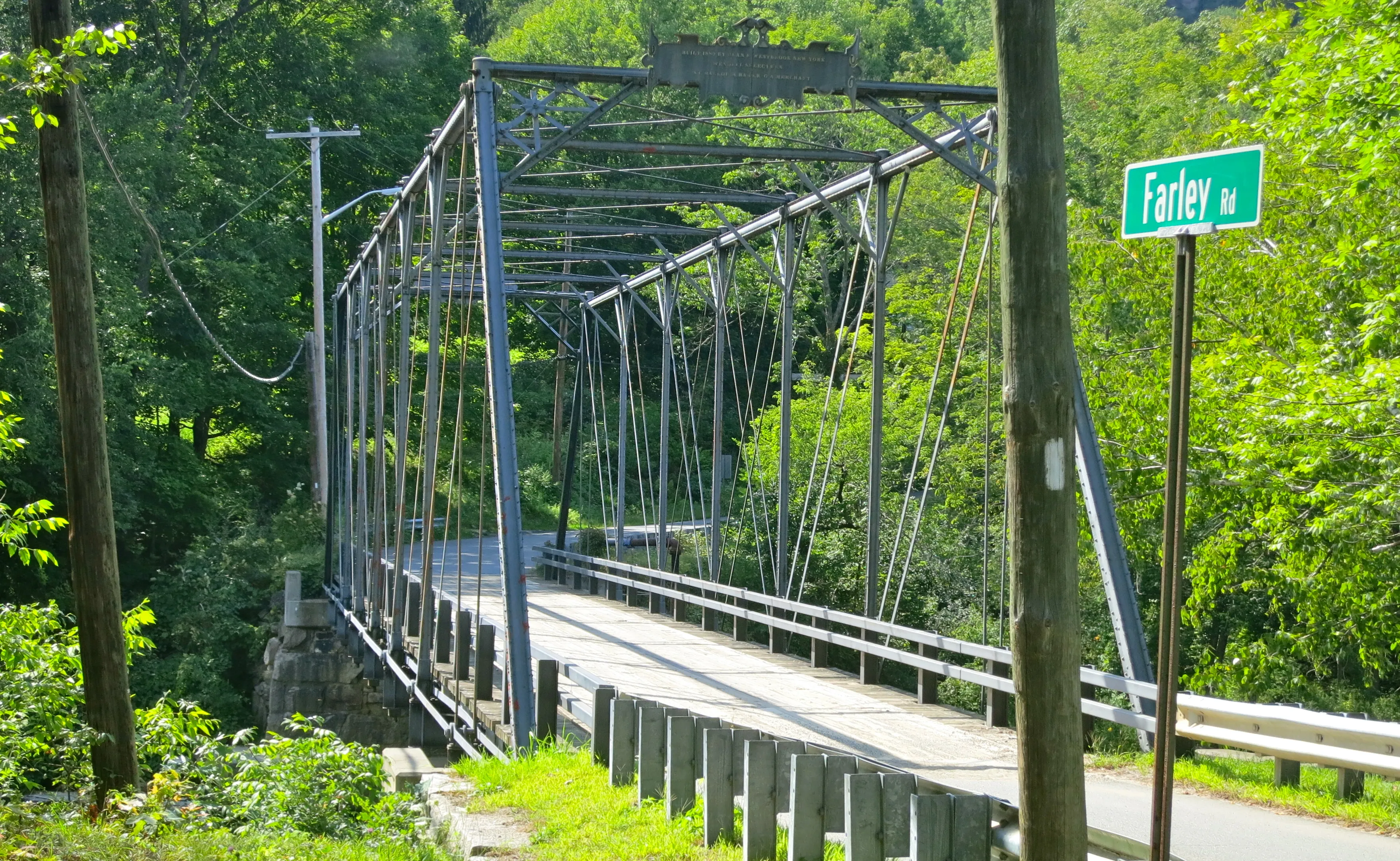
The Farley Road Bridge
The hero image is the Farley Road Bridge, a one-lane iron truss bridge crossing the Millers River into the village of Farley. Built in 1889, it is an eight-panel pin-connected Pratt through truss with Phoenix columns, fabricated by the Phoenix Bridge Company of Phoenixville, Pennsylvania, with Dean and Westbrook of New York as agents. The main span is about 123 feet and the roadway only 13.8 feet wide, so it carries traffic one direction at a time. It is one of the more intact-surviving 19th-century metal truss bridges in Massachusetts, with its decorative portal bracing and ornate maker’s plaque still in place.
Farley village
The east-end village of Farley, on both banks of the Millers River, was founded as a mill village in 1881–1883 by brothers D.E. and J.B. Farley and George Monroe, who bought land on both sides of the river, dammed it, and built a pulp mill. The operation grew quickly to include paper-making and a knitting works that ran some twenty Lamb knitting machines and produced roughly 10,000 dozen pairs of woolen and worsted mittens a year. The B&M railroad ran along the south bank with a depot in the village, and the river-and-rail-and-mill arrangement is what the period descriptions of Farley are picturing. The mills are long gone, but the dam, mill foundations, and a tight cluster of worker housing along Farley Road are still recognizable.
Erving Paper Mills
The town’s other paper operation, and its largest current employer, is Erving Paper Mills at the west end of town, the family-owned successor to the C. Elmer Pope Paper Company that Charles Elmer Pope launched in Holyoke in 1905. In 1908 Creighton W. Whiting bought the company and moved it to Erving; the new mill building was finished in 1910. It was sold and renamed Erving Paper Mills in 1916, and in 1927 Morris Housen, then an officer at Holyoke Savings Bank, was asked to take over and acquired the mill with his brother David. The Housen family still owns the operation, now branded Erving Industries, which continues to make tissue and napkin paper on the Millers River.
Erving State Forest
Erving State Forest is a 4,479-acre DCR property in the northern part of town, anchored by Laurel Lake, a small, clear pond with a public beach, a boat ramp, and a 27-site seasonal campground on the hillside above the water. About eight miles of forest roads and several trails run through oak, maple, and hemlock woods between the lake and the surrounding ridges. The mountain laurels along the lake bloom in mid-June, which is where the lake takes its name.
French King Bridge and the Connecticut
At the northwest corner of town, Route 2 leaves Erving and crosses the Connecticut River on the French King Bridge to Gill, the dramatic three-span steel cantilever-arch bridge opened in 1932, 135 feet above the water at the Erving–Gill town line, and named the Most Beautiful Steel Bridge of 1932 by the American Institute of Steel Construction. The bridge is covered in more detail on the Gill page.