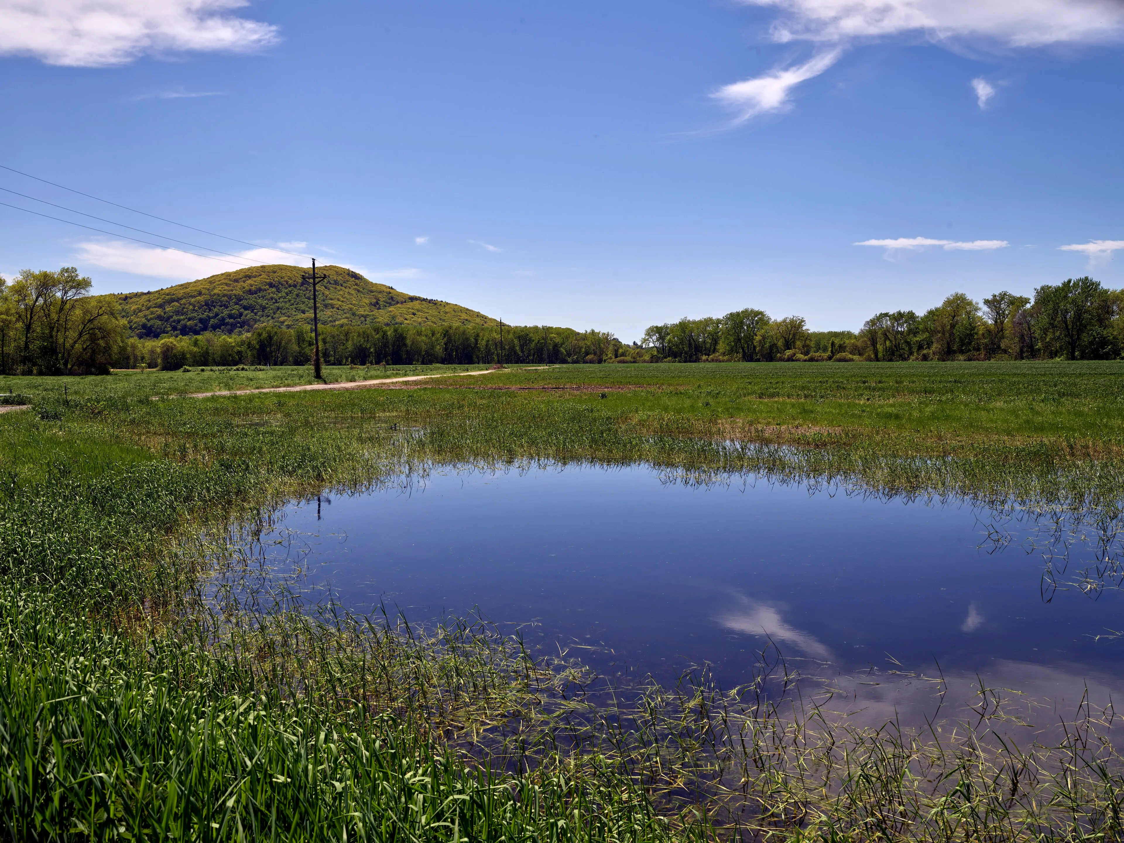
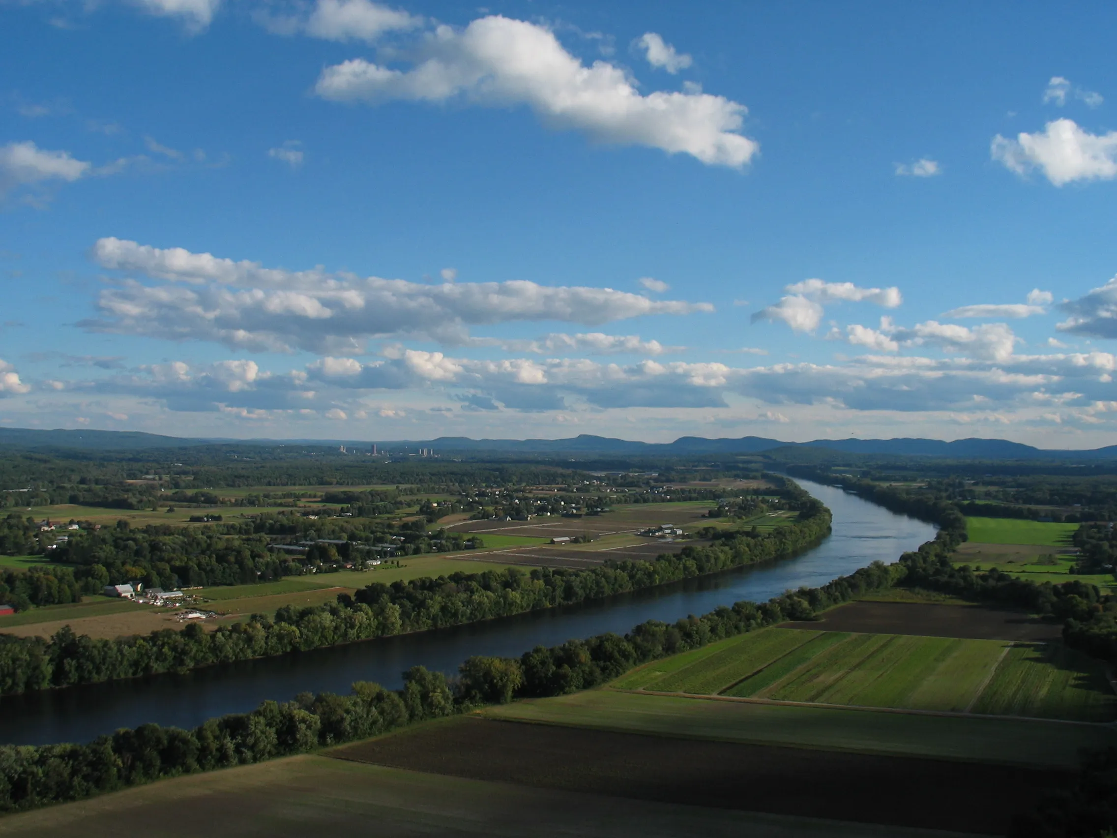
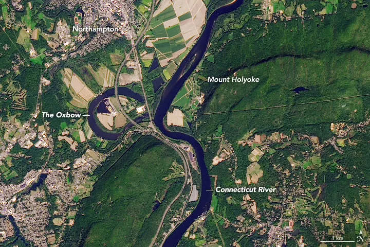
Arcadia Wildlife Sanctuary
A 751-acre Mass Audubon sanctuary on the Connecticut River oxbow in Easthampton and Northampton, with four miles of flat trails through marsh, meadow, and floodplain forest.
Easthampton · 4 mi · Easy
Section
Trails, parks, conservation areas, and waterways across the Pioneer Valley, verified and updated regularly.
A 751-acre Mass Audubon sanctuary on the Connecticut River oxbow in Easthampton and Northampton, with four miles of flat trails through marsh, meadow, and floodplain forest.
Easthampton · 4 mi · Easy
A flat 4.5-mile gravel loop around Holyoke's secondary drinking-water reservoir, with pine woods, open water views, and one of the most-used everyday running paths in the southern valley.
Holyoke · 4.5 mi · Easy
A Connecticut River recreation area on the Turners Falls impoundment. Paddle rentals, a campground, a short peninsula trail, and resident bald eagles nesting since the 1980s.
Gill
A small Trustees of Reservations property in New Salem where the Middle Branch of the Swift River drops about 12 feet into a hemlock-shaded gorge, reached by a short trail off Neilson Road.
New Salem · 0.4 mi · Easy
A roughly 3,500-acre DCR state forest in the hills west of Brimfield Center, with the Dean Pond Recreation Area as its developed core, the glacial-erratic Steerage Rock on the old Bay Path, and over twenty miles of multi-use forest roads and trails.
Brimfield · Easy
A 2,776-acre DCR forest in the Hampden County hilltowns spanning Chester and Blandford, established in 1924. The headline attraction is Sanderson Brook Falls, a 60-foot multi-tier cascade reached by a short walk from a forest road off Route 20.
Chester · Moderate
A 70-foot granite gorge cut by the East Branch of the Westfield River. A Trustees of Reservations property with a short cliff-edge overlook and a long riverside trail.
Chesterfield · Easy
A 1,048-acre state park strung along twelve miles of Connecticut River shoreline in eight discontinuous parcels, from Northfield down to Chicopee. The river's main public boat-launch and paddle-access network in Massachusetts.
Northampton
A 1,728-acre hilltown forest in Goshen and Ashfield, given to the Commonwealth in 1929 by the Daughters of the American Revolution. Upper and Lower Highland Lakes, a fire tower on Moore's Hill, a 51-site campground, and about fifteen miles of multi-use trails.
Goshen · Easy
The Deerfield River drops through Shelburne Falls over a bed of glacial potholes, with the Bridge of Flowers overhead and class II-III release-based whitewater upstream.
Shelburne
An eight-acre Trustees of Reservations site on Route 5 in Holyoke where exposed sandstone bedrock preserves 200-million-year-old dinosaur trackways, visible by a short seasonal trail from a roadside turnout.
Holyoke · 0.5 mi · Easy
A 2,422-acre DCR forest north of the Millers River in Erving, Warwick, and Orange, built around Laurel Lake, with a swimming beach, a seasonal campground, and a network of woods roads and trails through the rolling Franklin County uplands.
Erving · Easy
Northampton's largest conservation area. 936 acres around a 40-acre artificial lake, with boardwalks through wetland, a quiet beaver-pond loop, and nearly 10 miles of trails.
Northampton · 10 mi · Easy
Springfield's 735-acre city park, with an Olmsted-firm layout, a working zoo, a rose garden, a duck pond, and miles of walking roads and trails on the city's south side.
Springfield · Easy
A long, cascading waterfall on Glendale Brook in the hilltown of Middlefield. A Trustees of Reservations property with a short trail from the road to a viewing area beside one of the most powerful runs of falling water in Massachusetts.
Middlefield · 0.4 mi · Easy
A 2,432-acre DCR forest in the southern Berkshire foothills of Granville and Tolland, with the Hubbard River dropping 450 feet through cascades and pools, a small primitive campground, and a network of woods-road trails.
Granville · Moderate
A Mass Audubon sanctuary in the hills above Shelburne Falls, with about five miles of trails and a famous clifftop overlook taking in the Deerfield River valley and Mount Greylock on the horizon.
Shelburne · 5 mi · Moderate
A 200-million-year-old trap-rock ridge running east–west across the Pioneer Valley, with Mount Norwottuck at the center, the Notch on Route 116, the Horse Caves below the summit, and the New England Trail crossing the high ground.
Amherst · 8 mi · Moderate
An 843-acre state park on the western end of the Holyoke Range, donated to the Commonwealth in 1940. Mount Holyoke summit and the historic Summit House at the top, an auto road up the Hadley side, and meadows and ponds at the base.
Hadley · 3 mi · Moderate
A 5-mile hike past three of the five surviving 1841 Western Railroad stone arch bridges, 70-foot dry-stone keystone arches that predate the transcontinental railroad by decades.
Chester · 5 mi · Moderate
A US Army Corps of Engineers flood-control dam on the East Branch of the Westfield River in Huntington, completed in 1941. The basin is normally dry; the surrounding recreation area offers multi-use trails, picnic areas, river access, and big seasonal moods.
Huntington · 4 mi · Easy
A small Massachusetts DCR state park on the shore of Lake Wyola in Shutesbury. About 42 acres of woods and shoreline around a sand swimming beach, paddle-craft launch, and picnic grove on a 128-acre upland pond in the Franklin County hills.
Shutesbury · Easy
A 6-mile paved rail trail from Southampton through Easthampton to the Connecticut River, with the 2017 tunnel connection into Northampton linking it to the wider valley network.
Easthampton · 6 mi · Easy
The eastern Pioneer Valley reach of the long-running Mass Central Rail Trail. A patchwork of paved and stone-dust segments through Belchertown and Ware along the former Boston & Maine "Central Mass" line.
Belchertown · 7 mi · Easy
A roughly 6,000-acre DCR forest along Route 2 in Charlemont, Hawley, and Savoy, with the Cold River gorge, the Mahican-Mohawk Trail, a riverside campground, and one of the most significant stands of old-growth white pine in the Northeast.
Charlemont · Moderate
A 1,500-acre pitch pine–scrub oak barrens managed by prescribed fire. Rare habitat in New England and a reliable spot for grasshopper sparrow and whip-poor-will.
Montague · Easy
A 1,578-acre DCR forest in Warwick built around the 1,621-foot summit of Mount Grace, often cited as the third-highest peak east of the Connecticut River, with a steel fire tower the public can climb and the New England National Scenic Trail running over the top.
Warwick · 5 mi · Moderate
A 652-foot basalt ridge at the north end of the valley with a two-tier observation deck and one of the most-photographed Connecticut River views in Massachusetts.
South Deerfield · Easy
A 1,269-foot mountain east of the Connecticut River in Sunderland and Leverett, with a fire tower offering a 360° view at the summit, a glacial kettle pond, and several waterfalls along the lower trails.
Sunderland · 4 mi · Moderate
A 1,967-acre traprock ridge above the Connecticut River in Holyoke, with 22 miles of trails, Lake Bray, and a world-class fall hawk-migration lookout.
Holyoke · 22 mi · Moderate
A four-season recreation area on the lower slopes of FirstLight's Northfield Mountain pumped-storage project, with about 26 miles of multi-use trails for hiking, mountain biking, and cross-country skiing, a visitor center on Route 63, and the Connecticut River pavilion just downhill.
Northfield · 26 mi · Moderate
An 11-mile paved rail trail from Northampton through Hadley and Amherst to Belchertown. Flat, family-friendly, and usable year-round.
Northampton · 11 mi · Easy
A roughly 1,360-acre town park in Rowe. Pelham Lake at its center, a residents' beach and picnic area, and a network of trails through forested uplands.
Rowe · Easy
The public-access portion of the Quabbin Reservoir watershed in Belchertown. About 3,000 acres of woods, an auto loop, the Winsor Dam, the Enfield Lookout, and Quabbin Hill, all wrapped around Boston's drinking-water reservoir.
Belchertown · 6 mi · Easy
A boulder-choked glacial ravine in Leverett, walkable along an old town road now used mainly as a recreation corridor and a prime example of a New England post-glacial chasm.
Leverett · 2 mi · Easy
Roughly 1,025 acres along the Westfield River in Agawam, with more than 20 miles of trails through pine-oak forest and one of the larger undeveloped parks in the southern valley.
Agawam · 20 mi · Easy
A 1.2-mile universal-access loop through Connecticut River floodplain meadow and oak woodland, and one of the few fully wheelchair-accessible nature trails in Western Mass.
Hadley · 1.2 mi · Easy
A 300-acre private nonprofit park on the west side of Westfield, free to the public, with formal rose and rhododendron gardens, an arboretum, an Asian tea house, a covered bridge over Colonial Pond, and a 98-foot carillon tower.
Westfield · Easy
A 4,415-acre DCR forest in the southern Berkshire foothills wrapped around Otis Reservoir, a 1,065-acre lake with a boat ramp, swimming beach, and a peninsula campground that is one of the largest in the Massachusetts state forest system.
Tolland · Easy
A 7,566-acre DCR forest in the Franklin County uplands east of the Connecticut River. Ruggles Pond at the day-use core, Wickett Pond to the south, and miles of CCC-built woods roads through a rolling forested plateau.
Wendell · Easy
The southwestern Pioneer Valley's major river system, draining the Berkshire foothills through three branches that total 78 miles of federally designated Wild and Scenic water, the first such designation in Massachusetts.
Huntington · Moderate