Quabbin Park is the publicly accessible portion of the Quabbin Reservoir watershed: about 3,000 acres at the south end of the reservoir, in Belchertown, with an auto loop, several overlooks, a visitor center, and Quabbin Hill. The rest of the watershed (the other 80,000-odd acres of land and water) is closed to general access; Quabbin Park is the place the public is invited in.
A drowned valley
The Quabbin Reservoir was created in the 1930s by damming the Swift River with the Winsor Dam, flooding a 39-square-mile valley in central Massachusetts to supply drinking water to metropolitan Boston, 65 miles east. Four towns (Dana, Enfield, Greenwich, and Prescott) were taken by eminent domain, their residents relocated, and the cellar holes, roads, cemeteries, and town commons left behind beneath the rising water. The reservoir began filling in 1939 and reached full pool in 1946.
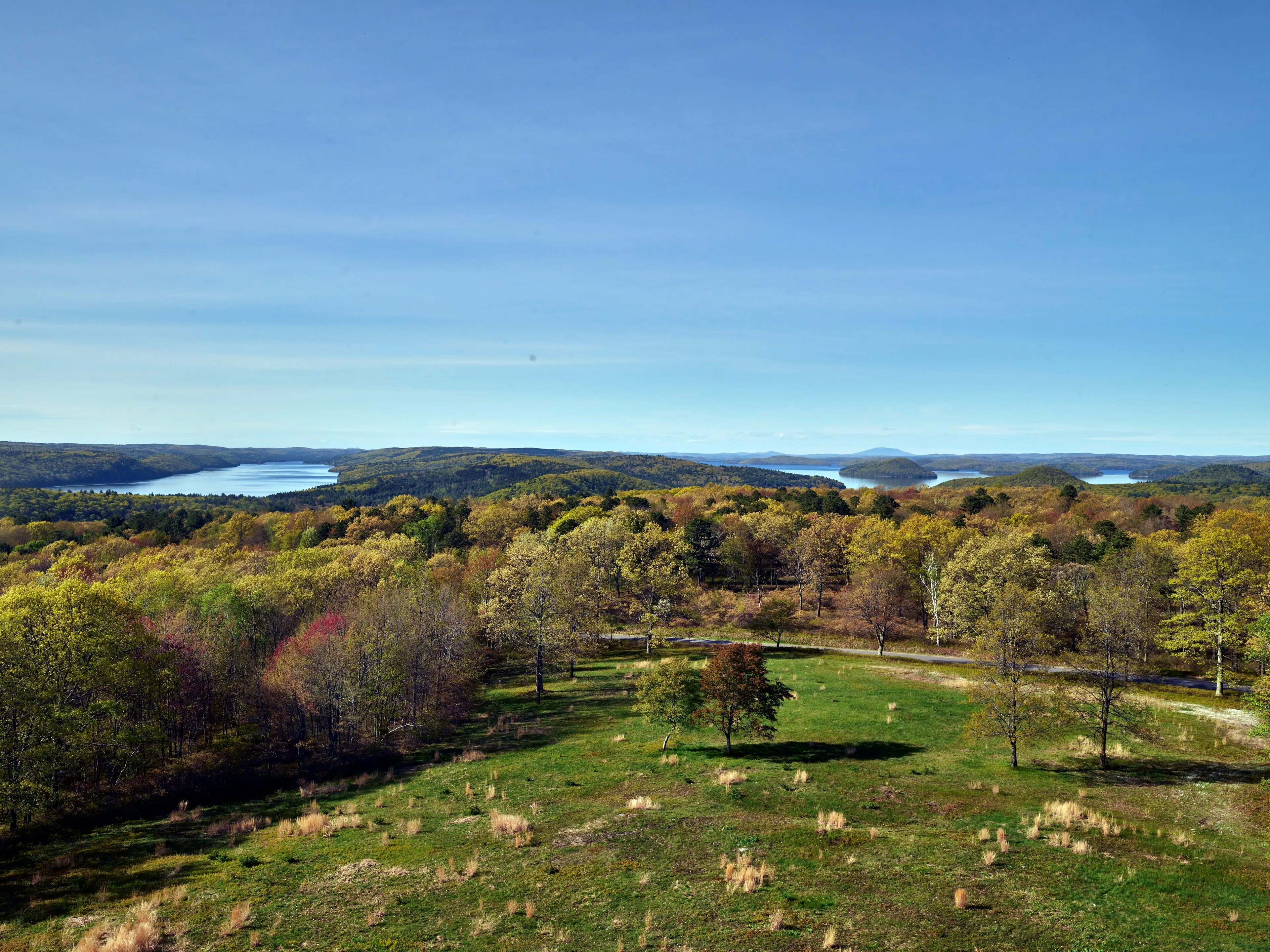
Most of what you see from Quabbin Park is the surface of that flooded valley: a long, irregular lake winding around the shoulders of the surviving hills, a few of which are now islands.
What’s in the park
- Winsor Dam at the south end: 2,640 feet long, 170 feet above the original riverbed. The walkway across the dam is open to foot traffic and gives the closest view of the reservoir’s full pool.
- Quabbin Visitor Center at the dam’s east abutment, a small DCR center with exhibits on the reservoir’s history, the four lost towns, the watershed, and the bald eagles that now nest on Quabbin’s islands. Free, open Thursday through Tuesday, 8:30 AM to 4:30 PM, and closed Wednesday.
- Enfield Lookout is a paved pull-off on the auto road named for one of the drowned towns, with a long view north up the reservoir’s main basin.
- Quabbin Hill and the Quabbin Tower, the highest point in the park, reached by a short paved road off the loop. The tower location remains open to visit, but DCR currently lists the observation tower itself as closed for renovations, so visitors cannot enter or climb it.
- Goodnough Dike at the southeast corner is the secondary dam that closes off the East Branch valley. Smaller, less visited, similarly walkable.
On foot
The auto road through the park is about six miles end to end, with short side spurs to each overlook and to the tower. Most visitors drive the loop; on foot it’s a long but easy walk on paved roads, and the gated dirt roads off the auto road open onto miles of woods walking on closed-to-traffic roadbeds.
The roads continue out of Quabbin Park proper into the rest of the watershed, where access is on foot only and the land is otherwise undeveloped. The watershed gates are numbered (Gate 8 in Pelham, Gate 35 in New Salem, etc.) and have small lots; this is some of the quietest backcountry walking in Massachusetts.
What to know
- No dogs. Quabbin is a public drinking-water supply and the entire watershed is closed to dogs, including dogs left in parked cars, and to swimming, wading, and any body contact with the water. Bring water for yourself, but do not enter the reservoir.
- Vehicle access. Vehicles must exit by the posted closing time. DCR listed vehicle hours as 6:30 AM-6:30 PM as of March 8, 2026, with times changing through the year.
- No swimming, no wading. Fishing is permitted from shore in designated areas with a Massachusetts license; private motorized fishing boats require a Quabbin Boat Seal, and private non-motorized boats are not allowed.
- Hunting. Limited deer hunt in season for population control; posted access closures during hunt weeks. Wear blaze orange in November.
- Bald eagles are commonly seen from the Enfield Lookout and the dam in winter and early spring; the reservoir is one of the state’s most successful eagle reintroduction sites.