Goshen is a small Hampshire County hill town of about 960 on the high ground at the western edge of the county, on Route 9 between Williamsburg to the east and the Berkshire foothills to the west. It was settled in 1761 and incorporated in 1781, set off from Chesterfield. Most of the town sits above 1,300 feet, and the town center, a small cluster of civic buildings around the Route 9 / Route 112 junction, is at about 1,400 feet, high enough that the climate runs noticeably cooler and snowier than the Connecticut Valley a few miles east.
Goshenite
Goshen’s most surprising export is a gem. The colorless variety of the mineral beryl (the same family that produces emerald and aquamarine) was first described from a deposit at the Barrus Farm in Goshen, and the gem-trade name goshenite has stuck ever since. Goshenite is the purest, most transparent form of beryl, hard (7.5–8 on the Mohs scale), and was historically cut into lenses for early eyeglasses, magnifiers, and small telescopes before optical glass became standard. Modern commercial sources are mostly Brazil, the Urals, and Pakistan, but the type locality remains the small Hampshire County hill town that gave the stone its name.
D.A.R. State Forest
The town’s largest landholding by far is the 1,728-acre D.A.R. State Forest, which spans Goshen and a small wedge of Ashfield to the north. The forest takes its name from the Daughters of the American Revolution, who donated the original 1,020-acre core to the state in 1929. The Civilian Conservation Corps did much of the early infrastructure work in the 1930s (dam reconstruction, the campground, the road and bridge network), and the property is run today by the Massachusetts Department of Conservation and Recreation (DCR).
The recreational center of the forest is Upper and Lower Highland Lakes, a pair of small connected ponds with a sand swimming beach, non-motorized boating, fishing, and a 51-site state campground on the Upper Lake shore. About 15 miles of multi-use trails run through the surrounding woods for hiking, mountain biking, and horseback riding in summer, and cross-country skiing and snowshoeing in winter. The Moore’s Hill fire tower at the high point of the forest is open seasonally and looks east across the Connecticut Valley and west into the Berkshires.
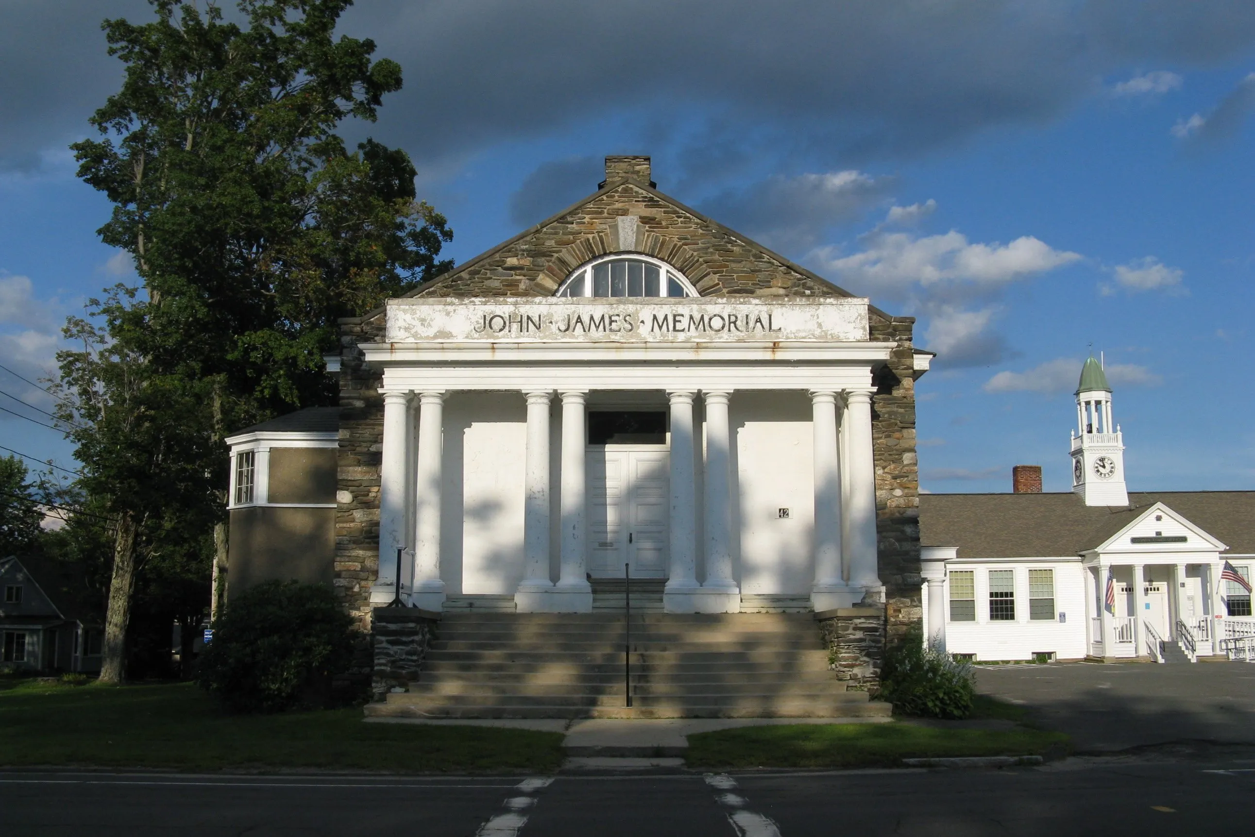
The town center
Goshen Center is small. The hero image is the John James Memorial (1911) on Main Street, a two-story fieldstone civic building designed by William J. Howes and built largely with a bequest from John James, a Goshen resident whose will funded most of the construction. The building houses an auditorium on the lower level and the town’s small Goshen Free Public Library on the upper floor, and was added to the National Register of Historic Places in 2018. A handful of other buildings (a small museum kept by the Goshen Historical Commission, the meeting house, and a few houses) sit within easy walking distance.
Other notes
- Camp Howe, a long-running summer camp on a tract abutting the state forest, has operated in Goshen since the early 20th century.
- The Institute for the Musical Arts maintains a recording studio and educational campus in town focused on women and girls in popular music.
- The Three Sisters Sanctuary, a private outdoor sculpture and performance garden along Route 112, is occasionally open to the public for events.
- Route 9 between Goshen and Conway to the northeast (via Whately and Ashfield) is one of the more scenic drives in the western part of Hampshire County, climbing steadily from the valley into the hill towns.
Sources
- Town of Goshen
- Goshen, Massachusetts — Wikipedia (2020 U.S. Census population: 960; incorporated 1781)
- D.A.R. State Forest (Massachusetts) — Wikipedia
- Goshen Town Hall — Wikipedia
- Goshenite (gem) — Wikipedia
- Goshenite — Mindat