Massachusetts has only a handful of surviving covered bridges left, and three of them (out of fewer than ten in the whole state) sit in the northwestern corner of the Pioneer Valley region, within about an hour’s drive of one another. They span three different small rivers, three different truss types, and a span of more than a century of bridge-building. A counterclockwise loop through Franklin County’s hill towns takes them all in over a half to full day, with plenty of room for foliage stops, a hill-town lunch, and a side trip on the Mohawk Trail.
This guide visits Burkeville Covered Bridge in Conway, Bissell Covered Bridge in Charlemont, and the Arthur A. Smith Covered Bridge in Colrain. The order below works well from a Greenfield or Deerfield base; reverse it if you’re coming in from the west on Route 2.
Stop 1: Burkeville Covered Bridge (Conway)
Start in Conway. The Burkeville Covered Bridge carries Main Poland Road over the South River in the small village of Burkeville, a short drive east of Conway center on Route 116. It was built in 1870, and what makes it unusual is the frame: a modified Howe truss in which the vertical members are iron rods used as tension elements, combined with timber diagonals and chords. It is believed to be the oldest surviving timber-and-iron-combination truss in Massachusetts. It was listed on the National Register of Historic Places in 1988 and reopened to one-lane vehicular traffic in November 2013 after a long rehabilitation.
There is no formal parking lot. The road is quiet and there are wide shoulders nearby; pull off, walk back, and take the time to look up inside the portal. The iron rods and timber framing are the whole reason the bridge is on the Register. The South River runs slowly under the deck. Drive through one car at a time and mind the weight limit. While you’re in town, the Field Memorial Library in Conway center makes an easy second stop, and the Conway common is a pleasant short walk.
Stop 2: Bissell Covered Bridge (Charlemont)
From Conway, head north up Route 116 and west on Route 2 (the Mohawk Trail) into Charlemont. About a mile north of Route 2 on Route 8A (North Heath Road), the Bissell Covered Bridge crosses Mill Brook. The current 92-foot Long-truss span dates to 1951, a near-replica of an 1840 original, built after the town objected to a proposed modern steel-and-concrete replacement of the failing earlier bridge. It was added to the National Register of Historic Places in 2004 and reopened to traffic after a 2008–2009 rehabilitation. It is one of just a handful of New England covered bridges still carrying full two-lane vehicular traffic.
A separated pedestrian walkway runs along one side, so the bridge is comfortable to cross on foot even though traffic still uses it. A short pull-off at the south end gives a side view of the bridge from above the brook. The drive from Conway to Charlemont takes about 25–30 minutes and is itself a nice piece of the trip. Route 116 climbs over the hills past Ashfield, then drops down into the Deerfield River valley at Shelburne Falls before joining Route 2.
If you want lunch, Charlemont center has a couple of small places, and Shelburne Falls (about ten minutes back east) has more. The Bridge of Flowers and Glacial Potholes in Shelburne make a worthwhile detour while you’re there. The Hail to the Sunrise statue, just east of Bissell on Route 2, is two minutes off the route.
Stop 3: Arthur A. Smith Covered Bridge (Colrain)
From Charlemont, take Route 2 east, then turn north on Route 112 (or follow the back roads through Heath) into Colrain. The drive is about 25–30 minutes through hill-town farmland and maple sugar country.
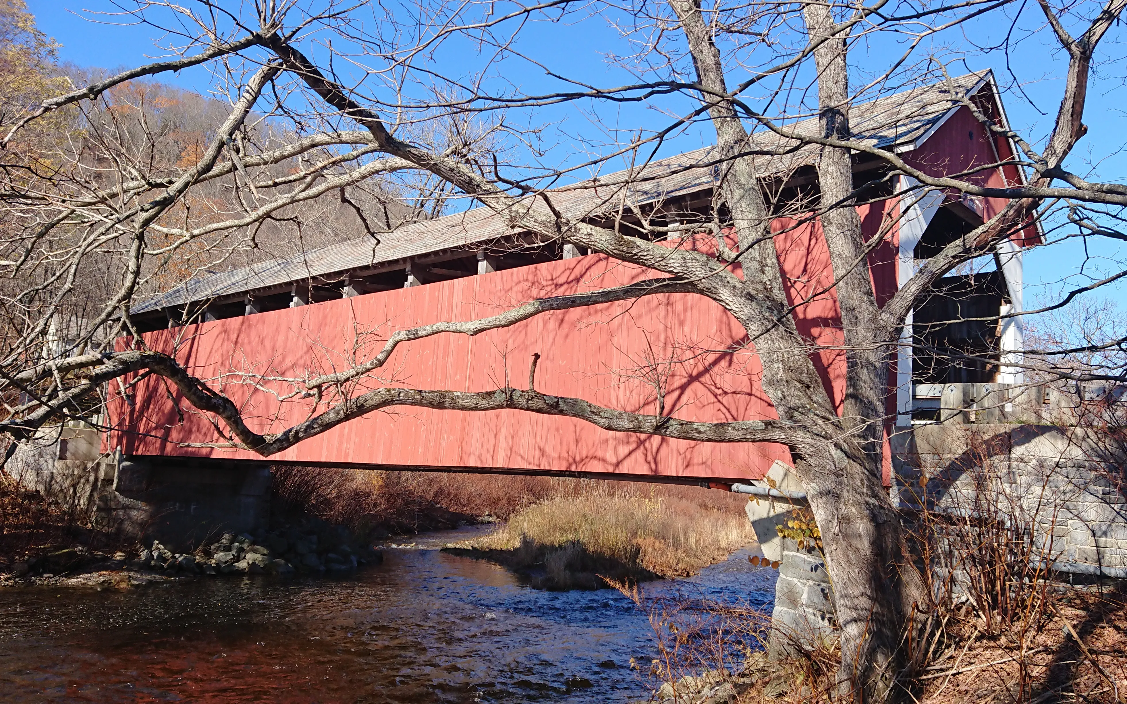
The Arthur A. Smith Covered Bridge is a 100-foot single-lane Burr-truss covered bridge that carries Lyonsville Road over the North River west of Colrain center, in the Lyonsville section. It was originally built in 1869 at a different crossing nearby and was moved to its present site in 1896; the bridge takes its name from Arthur A. Smith, a prominent local resident at the new site. It was added to the National Register of Historic Places in 1983, taken out of service in 1982, dismantled and rebuilt as part of a roughly $2.1 million reconstruction in 2007, and reopened to vehicle traffic in 2021. It is one of just two Burr-truss spans in Massachusetts.
The hero image at the top of this guide looks across the North River at the bridge from the south bank. Walking across is the best way to see the timber Burr truss. The long curved arch alongside the multiple-kingpost frame is unmistakable from inside. There is a small pull-off at one end; the rest of the road is quiet enough to park briefly and walk in.
Driving notes
- Total loop: roughly 60–80 miles depending on route, plus stops. Plan on a half day if you go straight through, a full day with lunch in Shelburne Falls and a Mohawk Trail detour.
- Drive times between stops: about 25–30 minutes Conway → Charlemont, and another 25–30 minutes Charlemont → Colrain.
- Direction: the order above (Conway → Charlemont → Colrain) is a counterclockwise loop from the I-91 / Route 2 corner near Greenfield. Reverse it if you’re starting west of the Valley on Route 2 from North Adams.
- All three bridges are free to view at any hour. There are no visitor centers or fees; the bridges are simply road crossings on quiet country roads.
- Each is one-lane (Burkeville and Arthur A. Smith) or has tight approaches (Bissell). Drive through one vehicle at a time and mind the posted weight limits.
- Seasonal access: the country roads connecting these towns are steep in spots and can be slick in winter. Late September through late October is the best window; the foliage in the hill towns peaks the first two weeks of October. Spring mud season (March into early April) is the hardest time of year for back-road driving.