The Quabbin is the strangest landscape in the Pioneer Valley. In the 1930s, four Swift River Valley towns (Dana, Enfield, Greenwich, and Prescott) were disincorporated by the Commonwealth on April 28, 1938, their houses moved or burned, their cellar holes flooded, and the river dammed at Belchertown to make a drinking-water reservoir for metropolitan Boston, 65 miles east. The dam went up between 1930 and 1939; the reservoir reached full pool in 1946. Today the Quabbin holds 412 billion gallons of water across 39 square miles, and the woods around it (closed to most public access to protect the watershed) are some of the quietest in the state. Bald eagles were re-established here in the 1980s and have been nesting on the islands ever since.
You can’t drive around the Quabbin proper, because the reservoir blocks any through-route, but you can drive a generous arc along its western and southern rim in a half day, with enough time at the lookouts and the gorge to stretch the trip into a full day. The route below runs from Belchertown up Route 202 / Daniel Shays Highway through Pelham to New Salem and back, with the long pause at Quabbin Park doing most of the sightseeing work.
Start: Quabbin Visitor Center (Belchertown)
Start at the Quabbin Visitor Center at the east abutment of Winsor Dam, just off Route 9 in Belchertown. It’s free and run by the Massachusetts Department of Conservation and Recreation, with interpretive exhibits on the lost towns, the construction of the dam, watershed ecology, and the return of the bald eagle. Allow 30–45 minutes, longer if you fall into the wall maps of the Swift River Valley as it was. The visitor-center lot is also the gateway to Quabbin Park.
Quabbin Park
Quabbin Park is the ~3,000-acre public-access portion of the watershed at the southern end of the reservoir, with a paved auto loop, several lookouts, and the Quabbin Hill observation tower. Drive west across Winsor Dam itself, half a mile of straight road across the top of the earthen dam, with the reservoir on the right and the spillway and the Swift River on the left, and continue up Quabbin Park Road to Enfield Lookout, named for the drowned town below. From the overlook, on a clear day, you can see across the water to the open hills of the eastern shore.
A few minutes farther on, climb Quabbin Hill for the 70-foot stone observation tower at the summit. The tower is a CCC-era structure of cut granite; on the deck you get the long aerial view of the reservoir’s southern basin and, on the clearest October days, Mount Monadnock to the north. Allow an hour and a half for the park loop with the tower stop; longer if you walk any of the fire roads.
Pelham
Leave the park and pick up Route 202 north, the Daniel Shays Highway, named for the Pelham farmer and Revolutionary War veteran who led the 1786–87 western-Massachusetts tax revolt that bears his name. Pelham is the small hill town strung along the highway on the west side of the watershed; it wasn’t one of the four disincorporated towns, but it lost a stretch of its eastern land to the reservoir, and Shays’ old hilltop farm sits within the town’s bounds.
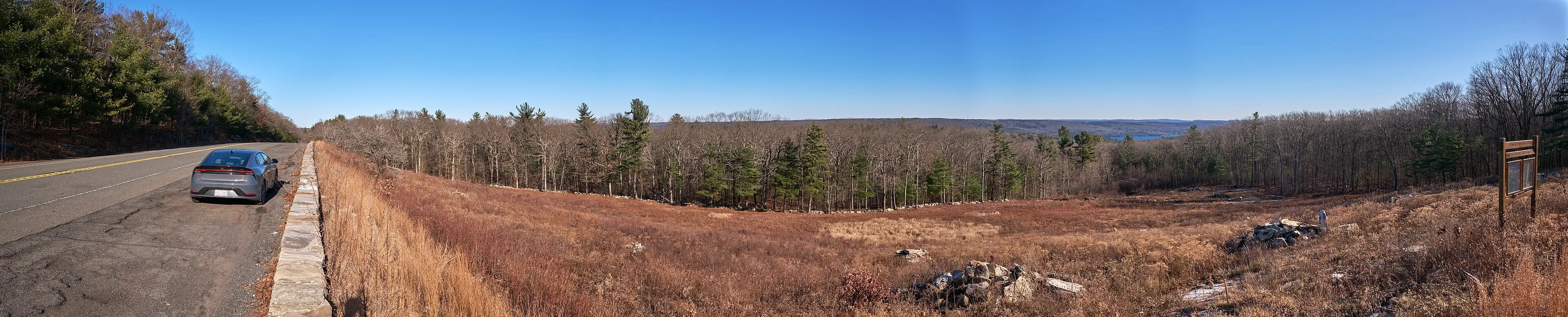
The white-clapboard Old Pelham Town Hall on Amherst Road, built in 1743, is what the town claims as the oldest town hall in continuous municipal use in the United States. It is a flat, plain two-story New England meeting house that has been the town’s seat since the year it was raised. A short walk uphill from the highway, it’s worth the five-minute stop. Farther north on 202, the Pelham Overlook pull-off is a wide shoulder with a long view east toward the watershed (the photograph at the top of this page was taken there).
New Salem and Bear’s Den
Continue north on Route 202 into New Salem. Of the towns whose territory was dissolved into the watershed, New Salem is the one that came out larger: when Prescott and the upland portions of Greenwich and Enfield above the waterline were disincorporated, New Salem annexed much of the land. The result is a town that’s geographically much bigger than its small village center. The New Salem Common historic district is a postcard of hilltop New England: a long oval green ringed with white-clapboard houses and the Swift River Valley Historical Society in a former 18th-century home, with rooms of artifacts moved out of the drowned towns before the flooding. Hours are seasonal and limited; check the society’s website before planning a stop.
A few minutes off the common, Bear’s Den is a small (~6-acre) Trustees of Reservations property with a 12-foot waterfall on the Middle Branch of the Swift River at the bottom of a 70-foot hemlock-shaded gorge. The walk in from the small gravel lot is short, under ten minutes, and the falls are a strikingly cold, dim pocket on a hot summer afternoon. The lot holds maybe six cars and fills up fast on autumn weekends; arrive early or stop on the way back through.
Practical notes
- The full perimeter of the reservoir is about 60 miles, but because the water blocks any direct east-west crossing in the middle, a true loop on Pioneer Valley-side roads only runs Belchertown → Pelham → New Salem and back. Add an out-and-back to Bear’s Den and the practical day’s driving is closer to 70 miles.
- Quabbin Park’s auto roads are open dawn to dusk, year-round in most years, but sections close for ice in winter and during hunting-season controlled deer hunts. Check the DCR site if you’re going in November or in deep winter.
- The Quabbin Visitor Center is free; closed on most major holidays.
- The Swift River Valley Historical Society is open seasonally and on limited days; defer to the society’s website for current hours.
- Bear’s Den’s parking lot is small and the falls trail is unmarked from the road; weekday or early-morning visits are easier.
- Fall foliage on the western Quabbin rim peaks in the first two weeks of October, a few days behind the higher hill country to the west.